Category 5 Hurricane Irma Headed for Florida

Meatpie

OWNER/ADMIN
Staff member
Administrator
Joined
Oct 7, 2008
Messages
61,301
Location
Bulgaria
LQPFzaj.jpg

Irma potential impact zones

Hurricane Irma now poses a serious threat to the USA and a state of emergency has been decalred for every county in Florida.

In the Caribbean, hurricane warnings were issued for 12 island groups, including Antigua, where the governor urged people to evacuate the tiny island of Anegada if they could ahead of the storm.

More updates soon.
 
Looks like it's heading on into the Gulf after Florida and/or Cuba - that isn't Houston straight in line with the end of the 'cone' is it?
 
fxQ89Ur.jpg


Still uncertain but most models suggest direct hit on Florida.

The National Hurricane Center predicts the storm will strengthen even more and may become the strongest hurricane on record.
 
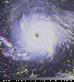
Latest satellite shows catastrophic event soon for the Leeward Islands

 
Ouch, not good! I'm guessing this one maybe be hard to call though - the slightest deviation south from that predicted line for the next few days brings it over a lot more land which i'm guessing would have a big effect on its strength and perhaps direction.
 
Irma is classic Cape Verde hurricane and will make history as one of the strongest storms ever recorded on Earth. Almost all Cape Verde hurricanes have done so in the past.

Read this:

https://en.wikipedia.org/wiki/Cape_Verde_hurricane

Most computer models suggest direct hit on Florida with great loss of life and populated areas wiped out.
 
HFXoQtr.jpg


National Hurricane Center calls Irma the strongest hurricane in the Atlantic basin ever recorded.

k22OfeC.jpg


Thanks Meatpie.
 
The island of Barbudas took a direct hit by CAT 5 Hurricane Irma yesterday - and it has been decimated. Widespread, total destruction reported.


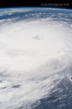
Spectacular view of the eye of Hurricane Irma, clearly visible from the International Space Station on Sept 5, 2017.

 
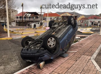
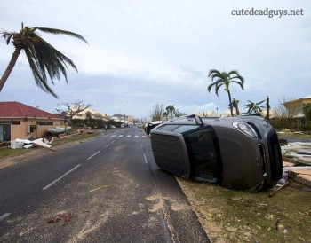
Cars Fly in Irma

New photos from Saint Martin released a few hours ago show winds of Hurricane Irma were so strong cars were lifted in the air and flipped over.


APWQW19.jpg


New Scientist: Hurricane Irma’s epic size is being fuelled by global warming

https://www.newscientist.com/article/2146562-hurricane-irmas-epic-size-is-being-fuelled-by-global-warming/?cmpid=SOC|NSNS|2017-Echobox&utm_campaign=Echobox&utm_medium=Social&utm_source=Twitter#link_time=1504778496


It’s a monster. As the eye of Hurricane Irma approached the tiny island of Barbuda this morning, wind speeds soared to 250 kph before the instrument broke.

At the time of writing, all contact with the island had been lost and it is unclear how the 1600 inhabitants have fared. But already reports of severe destruction are coming in from other islands in Irma’s path.
The destruction could be extreme. Hurricane Irma has the strongest winds of any hurricane to form in the open Atlantic, with sustained wind speeds of 295 kph.


It is also huge. The strongest winds are limited to a relatively small area around its centre, but hurricane-force winds of 118 kph or more extend out 85 kilometres from its eye.
Irma could yet grow stronger and is going to graze or directly hit many densely-populated islands in the Caribbean before possibly making landfall in Florida on Sunday – but there is still a lot of uncertainty about its path and intensity this far ahead.

Warmer waters

So why did Irma grow so strong? Most likely because climate change is making Atlantic waters ever warmer.
Tropical cyclones are fuelled by warm surface waters of around 26°C or more. They draw in moist air from all around them, and as it rises, the water vapour condenses out and releases latent heat, which drives further uplift. Irma’s clouds are 20 kilometres high.
However, as tropical cyclones grow stronger they churn up the ocean and bring deeper water to the surface. Usually this deeper water is cooler, and cuts off the energy supply.
The strongest hurricanes, then, can only grow if warm waters extend down to depth of 50 or 100 metres – conditions normally only found in the Gulf or Caribbean.
In 1990, Hurricane Allen reached 305 kph winds, fuelled by these warmer waters. In 2017’s warmer world, Irma began growing way out in the Atlantic, thanks to sea surface temperatures that were more than 1°C above average.

Stronger storms

Hurricane intensity depends on many other factors, too, though. For instance, winds high in the atmosphere are often faster than those lower down, blowing away rising air and preventing hurricanes from forming, or growing very strong. Low wind shear helped Irma grow into a perfect storm.
Computer models suggest global warming is likely to increase wind shear over the Atlantic, meaning there could no more or fewer hurricanes overall, but that storms grow stronger when they do form.
While tropical cyclones are currently ranked according to their wind speed, storm surges and flooding from high rainfall typically cause most of the damage, as we saw with Harvey.
The height of a storm surge depends not just on the strength of winds, but on their extent. Hurricane Sandy’s winds were not that strong but the size of the storm piled up the huge storm surge that caused most of the damage in New York and elsewhere.
So strong winds don’t necessarily mean big damage. The record is held by Hurricane Patricia in the eastern Pacific in 2015, with sustained winds of 345 kph. Fortunately Patricia was small, weakened dramatically before landfall and struck a sparsely populated area.
Irma, ominously, is both big and intense, and could cause big storm surges in highly populated places. Barbuda recorded a storm surge of 2.4 metres.
The amount of rainfall dumped by hurricanes can also vary widely depending both on a storm’s intensity, local factor and how fast it moves. Harvey produced huge amounts of rain because it barely moved for days.
Irma, thankfully, is moving faster – but its behaviour more than two or three days ahead remains highly uncertain.
 
rZcc0oV.jpg


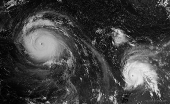
Morning satellite view shows three hurricanes currently churning in the Atlantic.

Center hurricane Irma, followed by Jose and Katia near Mexico.
 
The governor of Georgia issued a mandatory evacuation order for the city of Savannah minutes ago.
 
https://www.washingtonpost.com/news...ing-land-this-weekend/?utm_term=.b04f74083242

Current forecast is that Jose will hit Antigua and Barbuda, then curve north into the Atlantic well before the US though the end of the 'cone' looks perilously close to Bermuda:
https://img.washingtonpost.com/wp-a.../145650_5day_cone_no_line_and_wind.png&w=1484

Katia is forecast to track WSW into Mexico (Veracruz State) and remain relatively small though still no doubt very unwelcome.
Good luck to all CDG members in Florida, Bermuda if there are any, and the affected parts of Mexico!

I guess the remains of Jose, and possibly Irma, will track north to the jet stream and be carried our way, so perhaps reaching the UK in about a week. We never get hurricanes of course - far too cold - but when the remains of one get into the jet stream and reform as a mid-latitude depression, they still carry a lot of warm very moist tropical air so can form an unusually-intense storm with very heavy rain - the 'Hurricane Charly Storm' in the 1980s caused serious flooding in the Pennines and is still remembered.
 
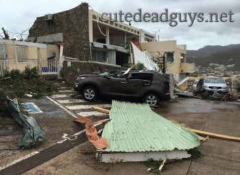
More flipped cars on St Martin.


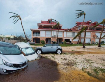
Damage in Orient Bay on the French Caribbean island of St. Martin after Hurricane Irma hit on Thursday.

Meanwhile hurricane Jose is expected to make landfall on Saturday as Category 4, bringing winds of up to 125 m.p.h. to the islands, threatening those whose homes were lost or damaged by the earlier storm.

 
VUSrVpK.jpg

Buildings were damaged by Hurricane Irma on the French side of the island of St. Martin on Thursday.

Some meteorologists expect hurricane Irma to strengthen to Category 5 again tomorrow and if it makes direct hit it could flatten Florida and render the peninsula uninhabitable for months.


Impressive satellite view of hurricanes Irma and Jose in close proximity. Irma has grown into a monster and will flatten Florida Jose is now Category 4 hurricane and will finish off the Caribbean islands. Meanwhile hurricane Katia will make landfall in Mexico in the next couple of hours as the country is still reeling from 8.1 earthquake that struck earlier today.
 
Back
Top