Hurricane Ophelia will bring Halloween heatwave to Europe as temperatures soar

Meatpie

OWNER/ADMIN
Staff member
Administrator
Joined
Oct 7, 2008
Messages
61,301
Location
Bulgaria
YZvUfJs.jpg

October heatwave in Europe next week due to global warming.

A blast of Indian Summer could be on the way as a tropical storm heads towards Europe.

Tropical Storm Ophelia is moving towards the UK with the mercury climbing up to six degrees above normal for the time of year in a rush of warm air preceding the storm.

Temperatures are tipped to top 18C later this week as the volatile tropical weather system drags milder air towards us from the mid-Atlantic.

Some forecasters are predicting the heatwave to continue until Halloween with warmer temperatures expected until the end of October.

The potent system, previously known as Tropical Development 17, is currently stationed about 800 miles from the Azores and has been gaining strength in the mid-Atlantic.

It is set to develop into an area of deep low pressure, picking up warmth from tropical areas of the Atlantic, before tracking north east.

The tropical storm could strengthen to hurricane status for a time while it remains in the mid-Atlantic, but should weaken before it heads to the UK.

It will move from the Azores later this week, heading across the Bay of Biscay on Sunday and towards Britain early next week.

The best of the weather in the North East this week is likely to be on Friday, with highs of 18C predicted.
The weekend forecast is also looking promising with bright sunshine and 17C warmth expected on Sunday.
The mercury is expected to fall early next week, but should still remain above average for the time of year.

Forecaster Eleanor Bell, of The Weather Channel, said: “Latest model guidance is indicating Ophelia will move in from the Azores across the Biscay area around Sunday and move on towards Britain early next week.
“This will push a plume of warmer air in from the south ahead of it. It is important to note we are still a week out and the models will likely vary in exact timing and position of Ophelia over the next few forecast runs.

“But we expect temperatures to be 4C to 6C above normal for the time of year over the weekend with a gradual cooler trend through next week.

“Above-normal temperatures could continue into Monday before getting cooler from Tuesday.
“However, temperatures are still set to be one or two degrees above normal.”
 
2SgDj64.jpg


New models by the national hurricane center suggest hurricane Ophelia may strike the UK with strong winds and heavy rain.

Tropical storm Ophelia has been upgraded to a CAT 1 hurricane this evening and is gradually moving towards Europe. Ophelia is centered just SW of the Azores with max sustained winds of 65 mph and a central pressure of 990 mb. This is the most west centered hurricane since Grace in 2009.

This is the 10th consecutive hurricane of the season.
 
Current forecasts suggest it is most likely to pass to the west of UK and Ireland, just far enough away for us to avoid anything serious - but that may change. And temperatures of up to 23C forecast for SE England over the weekend.
But the remains of Nate gave the Lake District up to 211 mm of rain yesterday - that's seriously high even for the Lakes!
 
Z2rSqEU.png


Hurricane Ophelia reached Category 2 a few hours ago. Latest models suggest direct hit to the UK.
 
Oh dear!
 
HktkHQv.png


Forecast models so far not looking good yeah. Ophelia is expected to make landfall in Ireland on Monday as a likely powerful windstorm with severe wind threat and torrential rainfall.
 
Detailed forecast keeps changing. Last one I saw predicted Ophelia further out from Galicia, but then swinging more NE to run over NW Ireland and into the Scottish Highlands - so NW Britain likely to get severe gales and torrential rain as you say, while SE England basks in sunshine and up to 25C.
 
YELYMWO.jpg

[SUB]Ireland hasn't been hit by such powerful storm in the last two centuries.[/SUB]

Hurricane Ophelia has been upgraded to category 3 storm with 115-mph winds and is forecast to hit Ireland with ferocious winds and lashing rain.

It's unusual for the UK to be included in the National Hurricane Center forecast.
:wtf:

Upper layers of ocean water in the North Atlanitc also unusually warm for this time of year due to global warming.

More updates soon.
 
Hurricane Ophelia just set new record for the farthest east tropical storm development in Atlantic basin.
 
Hurricane Ophelia made 2017 the only season in the satellite era that saw ten consecutive hurricanes.
 
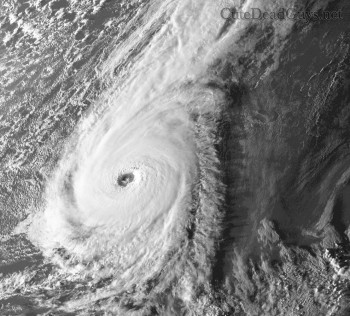
Latest satellite shows major Category 3 hurricane approaching Europe.

g0rTvTj.jpg

 
5qV7lxs.jpg


Weatherman Michael Fish, who in 1987 failed to predict one of the UK's most catastrophic cyclones, has said he would love to have a storm named after him.

The retired BBC forecaster famously told viewers not to worry hours before one of Britain's worst weather events in living memory, which left 18 people dead and caused around £1 billion of damage.

Speaking ahead of the 30th anniversary of the Great Storm of 1987, the most destructive since 1703, he said: “I would love to have a storm named after me.”
 
http://www.bbc.co.uk/weather/features/41622049 (not sure if this link will work for non-UK members).

This is bizarre - I've never seen a hurricane steaming straight toward us at full power! In fact I don't remember ever seeing a really intense mid-latitude depression coming in from the south. OK it ceases to be a hurricane sometime tonight or tomorrow, presumably because it loses its eye as it runs over cooler waters - but you can barely see the difference on the forecast vid, the windspeeds hardly drop and the central pressure doesn't rise.
Current forecast is for it run up the west coast of Ireland later on Monday, then across Scotland more-or-less along the line of the Great Glen. Conditions where I live forecast to be 'like a hair-dryer' on Monday (windy, up to 24-25C and this is mid-October!) with possibly damaging winds on Tuesday but hopefully I'm far enough from the stormtrack to miss the worst.
We live in 'interesting' times!
 
5qV7lxs.jpg


Weatherman Michael Fish, who in 1987 failed to predict one of the UK's most catastrophic cyclones, has said he would love to have a storm named after him.

The retired BBC forecaster famously told viewers not to worry hours before one of Britain's worst weather events in living memory, which left 18 people dead and caused around £1 billion of damage.

Speaking ahead of the 30th anniversary of the Great Storm of 1987, the most destructive since 1703, he said: “I would love to have a storm named after me.”

The exact quote is:
"Earlier on today apparently a woman rang the BBC and said she had heard a hurricane was on the way. Well I can assure people watching, don’t worry, there isn’t.” And as Meatpie says, 18 hours later 18 people were dead, the power was off for the whole of London, and half the trees in Sussex had been not just blown down but snapped off bodily. A relative in Sussex told me it was like having an express train pass over her house (though I'm not clear that had ever happened to her, they don't normally go over rooftops in a quiet area of Hove).

http://www.telegraph.co.uk/men/thin...l-fish-missing-great-storm-1987-saw-happened/

Weatherman Michael Fish on missing the Great Storm of 1987: 'when I saw what happened I thought, 'oh s***'
 
First time I've see such huge storm in the Atlanic so close to Europe. Here is latest visible satellite image just before sunset.

 
This will be a historic storm for the UK. The hurricane season of 2017 is headed to become the most active, deadliest and costliest hurricane season in recorded human history. 100mph winds expected to hit the UK.

XuNw056.jpg


Outflow cirrus from hurricane Ophellia reaches all the way to Norway.

FTLhFCS.jpg

 
Shit, that's worse than I'd heard - and I've never seen a depression that intense, the BBC weathermap isn't quite that bad.
but I can die happy - I've just spotted a website with a pic captioned 'The Royal Family at a Peasant Shoot, Sandringham', so my life is complete.
:super happy:
 
Met Office issues severe weather alert for whole of UK

Vo7l7zv.jpg


A severe weather warning have been issued as Hurricane Ophelia approaches the UK, however some areas will enjoy sunny spells before heavy rain and strong winds arrive.

The Met Office has warned of 80mph winds in coastal areas, particularly in Northern Ireland, as the remnants of Hurricane Ophelia hits on Monday.
But luckier parts of the UK will see temperatures rising to 25C over the weekend and escape the worst of the tropical storm on Monday.

A Met Office spokeswoman said: “The east side of the country certainly benefiting from some warmer temperatures into the weekend and at the start of next week.”
However, Monday will see a spell of "very windy weather" sweeping across western parts of the UK, according to the Met Office which has issued a yellow warning for wind early next week.

They have warned about potential power cuts, damage to buildings, flying debris and the possibility of disruption to transport and mobile phone networks.
“A spell of very windy weather is likely on Monday in association with ex-Ophelia,” they said.
“Road, rail, air and ferry services may be affected, with longer journeys times and cancellations possible.
“Power cuts may occur, with the potential to affect other services, such as mobile phone coverage.

“Some damage to buildings, such as tiles blown from roofs could happen, perhaps leading to injuries and danger to life from flying debris.

“Coastal routes, sea fronts and coastal communities may be affected by spray and/or large waves.”
It will coincide with the 30th anniversary of the Great Storm of October 15, 1987.
 
FKVjavq.jpg


Hurricane Ophelia is on th edge of becoming Category 4 storm. Weather warning updated to RED for West and South West Coast of Ireland tonight.
 
Back
Top