Beuen

Forum Resident
Joined
Nov 27, 2010
Messages
732
Location
Australia
First cyclone hits Queensland, but the big one is still building
Tom Reilly
January 31, 2011
THE upper reaches of Queensland's central coast were hit by a cyclone last night which battered some areas with winds of up to 140km/h.

The category two cyclone, named Anthony, made landfall near Bowen, 120 kilometres south-east of Townsville, at about 11pm and brought torrential rain to the state.

Rivers and streams stretching over more than 400 kilometres were on flood warning and areas between Bowen and Mackay were hit with more than 14 centimetres of rain yesterday. About 50 millimetres fell in the hour before 10.30pm.

It was unclear last night how much damage Anthony may have caused, but there may be worse to come: forecasters are predicting that a second, more powerful cyclone, called Yasi, will hit the state on Thursday.

The Queensland Premier, Anna Bligh, admitted it "would be easy to think somebody up there has got a grudge against us," as she warned Queenslanders yesterday to prepare for the powerful weather systems.

Ms Bligh described the two weather systems as "David and Goliath". Anthony was expected to be "quite smaller than the second event" which could cause winds well in excess of 200km/h.

"All disaster groups in the vicinity are on full alert and evacuation centres are ready and able to take people [after] the event, should they be needing shelter out of their own homes," Ms Blight said.

She also sought to reassure people that emergency workers, some of whom have been battling floods since November, would be ready to deal with the aftermath of the cyclones.

"They have had ample opportunity to replenish themselves and restore supplies. We are not battle weary, we are battle ready," Ms Bligh said.

The Bureau of Meteorology's Queensland regional director, Jim Davidson, said it was unusual to get an accurate forecast on Yasi so far in advance, but all of the modelling predicted a large "disturbance."

http://www.smh.com.au/environment/w...big-one-is-still-building-20110130-1a9pw.html
 
Not good

Doesn't look good, esp Yasi. That's a major hurricane that's gonna hit within 48 hours.

2927519e.jpg


If it doesn't weaken there will be major flood.

:unreal:
 
This one was a little one in comparison in 2008.

 
Some forecasters say it will strengthen to a category 4 storm, let's hope people manage to prepare in time, there will be damge - this is certain because the sea water is very warm and Yasi is strengthening.
 
Cyclone Yasi a triple threat to Queensland's north coast
Rosanne Barrett From: The Australian February 01, 2011 12:00AM

TROPICAL cyclone Yasi is emerging as a triple threat to Queensland's highly populated north coast, bringing with it destructive winds, storm surge and heavy rains.

The cyclone is expected to cross the coast between Innisfail and Proserpine -- with Queensland's northern capital of Townsville directly in its path -- overnight on Wednesday as a Category 2 system, bringing wind gusts of up to 275km/h and heavy rain.

Authorities are also extremely concerned about possible storm surges and flooding, advising residents in low-lying waterfront areas to relocate to higher ground.

Queensland disaster co-ordinator Ian Stewart yesterday warned north Queensland residents used to tropical cyclones not to underestimate the system.

"Relocation should be considered by people in low-lying areas. This is a very, very serious threat to the safety of our coastline and the safety of our community," he said.
The cyclone strengthened to a Category 3 storm on Monday with winds up to 185 km/h, and is expected to strike the Queensland coast on Wednesday or Thursday as a Category 4 storm with gusts up to 260 km/h.

The coastal region is home to more than 310,000 people, including Queensland's second-largest city of Townsville, with 180,000 people, and the growth hub of Mackay, population 80,000. But the coastline is also dotted with towns of just under 10,000 people, including Innisfail, Ayr and Bowen, and towns with between 3000 and 5000 people, including Ingham, Mission Beach, Tully, Home Hill and Proserpine.

Winds of more than 100km/h will buffet the area by mid-morning tomorrow.

Strong building codes have been in place since the 1960s in north Queensland, in a bid to ensure properties are better protected against cyclones and authorities have advised residents -- other than people in low-lying waterfront areas -- to remain in their homes. Heavy rain, including predictions of dumps of more than a metre, will spread south and inland from where Yasi crosses the coast, and is expected to inundate already sodden catchments of the central highlands.

Modelling for the cyclone has been consistent for five days, pointing to it keeping its predicted course.

Queensland's current weather is the result of the intense La Nina weather system that continues to dominate the Pacific Ocean.

Australia's National Climate Centre has recorded it as one of the strongest La Nina events on record, and it is likely to persist through to autumn.

"While we have such an intense La Nina we have to stay on guard, and be prepared in a risk-management setting even a bit further south than usual," University of Southern Queensland professor of climatology and water resources, Roger Stone, said. "In La Nina years, not only is the sea temperature warmer, the (sea) level is higher as well.

"The intense low pressure and strong winds, they can create a very strong surge of water hitting the coast, and depending on the speed of that water they can do a lot of damage."

http://www.theaustralian.com.au/new...ands-north-coast/story-e6frg6nf-1225997705117

Read more: http://www.cbc.ca/world/story/2011/01/31/australia-cyclone-yasi.html#ixzz1CdAS4ivO
 
I love Australian accent.
 
How Yasi compares with past cyclones (courtesy of The Courier-Mail):


5.24pm: Parts of Cairns will see a storm surge of up to 2m when Cyclone Yasi hits, expected to be about 1am (AEST) on Thursday. State disaster management coordinator Ian Stewart said the storm surge would be lower than originally feared, but would still be very significant. "I can't give specific street names but certainly, I've seen the (electronic) map and it's quite extensive,'' he said. Metropolitan Cairns would see significant inundation, he said.

5.07pm: Snippets from Queensland Premier Anna Bligh's latest update: "This storm is huge and it is life-threatening ... I know many of us will feel that Queensland has already borne about as much as we can bear when it comes to disasters and storms, but more is being asked of us - and I am confident that we are able to rise to this next challenge."

4.46pm: Forecasters say severe tropical cyclone Yasi is on track for a direct hit on Cairns, but that could still change before it makes landfall about 1am (AEST) on Thursday.

4.42pm Airlines have hit back at reports they were hiking up their fares to take advantage of the exodus from Far North Queensland as the region prepares for Cyclone Yasi. A Qantas spokesman said it was charging standard commercial rates, and Jetstar spokesman Simon Westaway said its fares from Cairns were normal.

4.16pm A gallery of the worst cyclones of Australia's history could be an indication of the kind of damage Yasi might bring.

http://www.news.com.au/pictures/gallery-e6frflv9-1225998123479
Read more: http://www.news.com.au/breaking-new...it/story-fn7ik2te-1225997552623#ixzz1ChTwwFm0
 
Thanks man, keep up us updated, looks like major disaster looming
 
Yasi is potentially bigger than Cyclone Nargis in 2008 in Asia, which left over 130,000 people dead. Most people have been evacuated, so I expect the death toll won't be as high. There's bound to be some though.
 
I am in Aus and I am expecting wat the Yasi can cause =]
 
I gather cyclones can bring deadly hailstorms like this one. Wouldn't like to be out in a hailstorm, be like deadly ice bullets raining from the sky. Imagine if one hit you on the head. on second thoughts better not imagine that, lol.

 
Cyclone and Hurricane
We often come across the terms cyclone and hurricane and suppose it to be the same thing. In fact cyclone and hurricane are terms representing two different things. A cyclone is a forceful wind, usually violent in nature, which rotates clockwise in a closed area. Cyclones originate in the Southern Hemisphere of the Earth. Hurricanes also are forceful winds, but these originate in the Northern Hemisphere and spin in the anti-clockwise direction.

A hurricane is often referred to as “Tropical Cyclone” as it is a tropical low pressure storm system. The major difference in the blowing strengths of both these winds are that during a cyclone, a house can be blown apart as a whole, while with a hurricane the house can be blown down to pieces. A hurricane is often accompanied by heavy rains and cyclones are accompanied stormy, destructive weathers. The intensity of the winds depends on the accompanying rains and weather. But hurricane is considered stronger than a cyclone owing to the destruction being caused. Hurricanes have a wind speed of more than 74 miles per hour. The calm area over which these winds blow is known as The Eye.

Read more: Difference Between Cyclone and Hurricane | Difference Between | Cyclone vs Hurricane http://www.differencebetween.net/science/difference-between-cyclone-and-hurricane/#ixzz1CijlNxfu

 
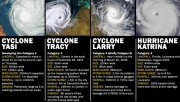
Yasi now Category 5 - rivaling Katrina . 600 km across.


http://www.news.com.au/

Count down to Cyclone Yasi 3 hours 40 mins expect tidal waves 9 m high

IDQP0005
Australian Government Bureau of Meteorology
Queensland
Tropical Cyclone Warning Centre

Media: Transmitters serving the area from Cape Flattery to Sarina and inland to
areas east of Croydon to Richmond are requested to USE the Standard Emergency
Warning Signal before broadcasting the following warning.

TOP PRIORITY
TROPICAL CYCLONE ADVICE NUMBER 19
Issued by the Bureau of Meteorology, Brisbane
Issued at 6:59pm EST on Wednesday the 2nd of February 2011

A Cyclone WARNING is current for coastal and island communities from Cape
Flattery to Sarina, extending west across the tropical interior to the Northern
Territory border.

At 7:00 pm EST Severe Tropical Cyclone Yasi, Category 5 was estimated to be 150
kilometres east northeast of Innisfail and 175 kilometres east of Cairns and
moving west southwest at 29 kilometres per hour.

SEVERE TROPICAL CYCLONE YASI IS A LARGE AND VERY POWERFUL TROPICAL CYCLONE AND
POSES AN EXTREMELY SERIOUS THREAT TO LIFE AND PROPERTY WITHIN THE WARNING AREA.

THE VERY DESTRUCTIVE CORE OF CYCLONE YASI WILL CROSS THE COAST NEAR INNISFAIL
CLOSE TO MIDNIGHT, ACCOMPANIED BY A DANGEROUS STORM TIDE SOUTH OF THE CYCLONE
CENTRE.

Tropical Cyclone Yasi, CATEGORY 5, will continue to move in a west-southwesterly
direction and is expected to cross the coast near Innisfail close to midnight.

Coastal residents between Cairns and Ayr are specifically warned of an EXTREMELY
DANGEROUS SEA LEVEL RISE [i.e. storm tide] as the cyclone approaches, crosses
the coast and moves inland. The sea is likely to steadily rise up to a level
which will be VERY DANGEROUSLY above the normal tide, with EXTREMELY DAMAGING
WAVES, STRONG CURRENTS and FLOODING of low-lying areas extending some way
inland. The storm tide will persist for many hours after landfall of the cyclone
and secondary peaks may occur around high tide on Thursday morning. Higher than
normal tides will exceed the high water mark with damaging waves and flooding in
low lying areas in remaining warning areas to the south of Ayr.

People living in areas likely to be affected by this flooding should take
measures to protect their property as much as possible, and be prepared to
follow instructions regarding evacuation of the area if advised to do so by
authorities.

DESTRUCTIVE winds with gusts in excess of 125 km/hr between Port Douglas and Ayr
are expected to spread into the eastern tropical interior overnight. VERY
DESTRUCTIVE winds with gusts up to 290 km/hr are expected to develop between
Cairns and Ingham during the next few hours as the cyclone approaches and
crosses the coast near midnight. These VERY DESTRUCTIVE winds will also occur to
the north of the cyclone and affect the Atherton Tablelands.

Due to the large size of the cyclone, people in the path of the VERY DESTRUCTIVE
WINDS are likely to experience these conditions for about 3 to 4 hours.

DAMAGING WINDS with gusts to 90 km/hr are occurring in remaining coastal areas
between Cape Flattery and Sarina, and are forecast to spread into the tropical
interior overnight and west to Mt Isa during Thursday.

Winds are forecast to gradually ease about the east coast during Thursday
morning as the cyclone moves inland.

FLOODING RAINS will develop from Cooktown to Sarina during this evening and then
extend inland overnight.

People in the path of the very dangerous cyclone should stay calm and remain in
a secure shelter, above the expected water level, while the very destructive
winds continue.
- Do not venture outside if you find yourself in the eye of the cyclone; very
destructive winds from a different direction could resume at any time.
- Follow the evacuation advice or directions of Police, Emergency Services
personnel and local authorities.

People in remaining areas between Cape Flattery and Sarina and extending west
across the tropical interior to the Northern Territory border, should complete
preparations quickly and be prepared to shelter in a safe place.
- Boats and outside property should be secured.
- For cyclone preparedness and safety advice, visit Queensland's Disaster
Management Services website [www.disaster.qld.gov.au]
- For emergency assistance call the Queensland State Emergency Service [SES] on
132 500 [for assistance with storm damage, rising flood water, fallen trees on
buildings or roof damage].

Details of Severe Tropical Cyclone Yasi at 7:00 pm EST:
.Centre located near...... 17.2 degrees South 147.4 degrees East
.Location accuracy........ within 20 kilometres
.Recent movement.......... towards the west southwest at 29 kilometres per hour
.Wind gusts near centre... 285 kilometres per hour
.Severity category........ 5
.Central pressure......... 930 hectoPascals

http://www.bom.gov.au/cgi-bin/wrap_fwo.pl?IDQP0005.txt
 
Back
Top